
How Morgan County Property Search Starts
The WV Property Assessment site is the natural first stop. It serves a Morgan County property search well. It takes several keys in one place. A street-name query returns a group of parcels. An owner query surfaces everything held under one name. A full parcel ID gives the tightest match of all. The Morgan County Assessor site adds map cards and land books. The County Clerk's scanned-records link is a separate door into recorded deeds and other documents. No single query answers every land, tax, and title question. Plan on more than one.
- Choose County=Morgan, then search the Street Name, Owner Name, or Full Parcel ID field.
- Open the candidate result and record its owner, district, map/parcel, acreage, and legal description.
- Carry its deed book/page or grantee name to the Morgan County Clerk's recorded-land system.
- Use the Assessor roll for values and the GIS viewer for location; use the Sheriff for a bill.
- Ask the custodian for a copy or help when a web record is missing or unclear.
Morgan County Assessor Search Fields
The Assessment form offers Basic, Appraisal/Sales, Advanced, and Prior Ownership modes. Most controls are optional. Enter one field at a time, since a spelling difference or an unknown district can hide an otherwise good result. The Morgan County form includes these useful search keys:
| Field | Type | Morgan County use |
|---|---|---|
| County and District | Dropdowns | Set Morgan; use a district only when known |
| Owner Name and Street Name | Text | Search a name or list parcels on a road |
| Full Parcel ID, Map, Parcel, Sub-Parcel | Text | Match a tax-map key |
| Deed Book and Page | Text | Connect the roll entry to the Clerk |
| Sale From/Through and Min/Max Price | Date and number pairs | Filter displayed sales data |
| Legal Description and Mailing Address | Text | Search old lot wording or tax mail route |
More fields cover class, land use, appraisal ranges, acreage, and flood hazard. Building year, structure count, and area can be narrowed too. The form can also show legal text and a GIS parcel ID. Those are the live controls in the WV application. The legacy Clerk portal's fields and online cutoff are another matter. The Clerk's office can describe them directly. Open the WV Property Assessment search for Morgan County to see the current form.
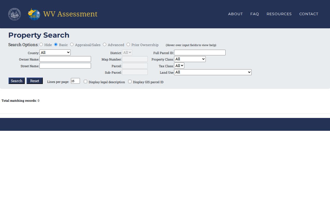
Set the county before you type a road, owner, or parcel query. That keeps every result local to Morgan County.
Street and Mailing Address Keys
The Assessor form separates Street Name from Mailing Address. The first points to the land's situs. The second is where the tax bill goes. That split matters for absentee owners, route addresses, and older deeds that describe a rural road rather than a modern street number. A Berkeley Springs street query can return several map and parcel entries, so never pick a result on street text alone. Older Berkeley Springs material may say Bath, while today's address and office pages use Berkeley Springs. Keep both words as search variants in a town-edge search, then compare the tax district, parcel, and legal description before settling on a match. A street search finds candidates. It is not a municipal-boundary test. For a new or uncertain address, Morgan County GIS/addressing offers address-verification and address-request forms.
Reading a Morgan County Parcel ID
The statewide parcel identifier has six parts. These are county code, district code, map number, parcel prefix, parcel suffix, and special ID. County and district codes are numeric. The rest can be letters or numbers. Morgan County results may show an unhyphenated full PID. A state example may use hyphens. Copy the ID exactly as displayed instead of rebuilding it by hand. That same key then works in the GIS viewer and in a map-card request. When the full key is unknown, the Assessor helps. It provides separate Map Number, Parcel, and Sub-Parcel fields. They are more exact than a street name. Even so, they can return a candidate that still needs comparing. Keep the county and district codes alongside the parcel parts in your notes. A clipped or mistyped ID can point to a neighboring parcel. So the situs, owner, acreage, and legal description should all agree before you carry a result into a deed search.
What a Morgan County Parcel Result Shows
A Morgan County result is more than an owner name. The sample record for PID 33060017001200010000 shows tax year 2017 and class 2. The owners are Joey L. and Jane E. Kerns. The card lists a Berkeley Springs situs and mailing line. It also shows deed reference 156/684 and the legal description "DRNS SLEEPY CREEK 2.00AC PT PCL A LOT 1." Values split into land, building, and total. Read the year and field labels. Then compare this card with a current tax bill or a recent sale.
| Owner Name | Owner shown on the annual assessment roll |
|---|---|
| Situs and mailing | Land address and separate tax-mail address |
| Parcel key | County, district, map, parcel, and sub-parcel fields |
| Appraisal | Land, building, and total figures with a tax year |
| Legal description | Abbreviated tract, acreage, part-parcel, and lot language |
| Deed reference | Book and page used to seek the recorded instrument |
The sample card shows why a search result is a bridge, not a final opinion. A description naming Sleepy Creek is a clue toward a deed or plat. It does not prove a current formal subdivision carries that name. A displayed owner is the Assessor's owner-of-record field. It is not a guarantee that no later document or interest exists. When the question is title or transfer history, retrieve the instrument itself. The Morgan County parcel-detail example displays the owner, deed reference, acreage, description, and value fields.
- Parcel ID
- A tax-map key made from county, district, and parcel parts.
- Situs address
- The location assigned to the land, distinct from its tax-mail address.
- Owner of record
- The name carried on the Assessor's roll for a stated assessment year.
- Legal description
- The land wording that ties an entry to deeds, plats, and acreage.
Compare Morgan County Search Keys
Pick the Morgan County search key least likely to change. A street is easy to recall, but it may have a rural or historic form. An owner name can uncover several holdings, yet it may carry initials, a trust, or an LLC. A parcel ID is precise once you have it. For older records, the deed book and page plus the legal description often beat a current street address. They carry the recorded land reference itself.
| Search Key | Best For | Where It Works | Watch Out |
|---|---|---|---|
| Street name | Locate candidates along a road | Assessor and GIS | Several parcels may share one street |
| Owner name | Find roll entries tied to a person or entity | Assessor and Clerk | Initials, same names, estates, and LLCs can differ |
| Parcel ID | Match one tax-map record | Assessor, map viewer, and Auditor | Copy the complete key from the result |
Not a title search. A Morgan County property search identifies records to review; it does not certify clear title or replace a lawyer or title professional's examination.
Morgan County Map Cards and Land Books
The Morgan County Assessor offers two research tools for digging into older assessment records. Its map-card viewer is organized by District and Map/Parcel. The office handles copy requests directly. The Land Book Viewer works differently. It lets you pick a Year and a Book/District combination. That makes it handy for tracing an assessment entry from one tax year to the next. Both are assessment products. For title and boundary questions, the Clerk's deed records or a survey still govern.
Say a modern property search points you back to an older tax year. Note the year, district, map, and parcel before you open a card. That discipline saves time. Comparing a map card against the legal description on the assessment roll can explain how a parcel was valued and described in that era. It cannot tell you when the current deed was recorded. So do not treat it as a conveyance record. The Assessor's 2026 notices said its real-property books were still processing online. Phone the office about any gap before assuming a book never existed.
The Morgan County map-card viewer shows the District and Map/Parcel controls.
When Morgan County Search Results Differ
Search results in Morgan County sometimes disagree with each other. A freshly recorded deed can reach the Clerk well before the statewide property Viewer shows the new owner. This is because assessment data refreshes just once a year. A parcel boundary can lag too. The ownership instrument may already sit in Clerk custody. Meanwhile, the map may still show the old outline. These are separate update paths, not signs that a record is wrong.
A street or owner search may return several candidates. Compare district, map/parcel, acreage, situs, and legal description until one match stands out. When fields conflict, trust the newest recorded deed for the conveyance itself. Then ask the Assessor about a roll error or a delayed map revision. The official county text does not spell out the Clerk's online coverage or search fields. Details may need a call. A document missing online may still exist at the public counter, in older books, or on Archives microfilm. The fee schedule tells you the cost. Never build a title chain from a search-result label alone.
Morgan County Entity Owners
Morgan County sometimes assesses property to a company instead of a person. Sample results from the county include Sugar Maple Property Ventures LLC. The company appears on two Wilkes Street parcels in the Berkeley Springs Corp district. When that happens, search the exact organization name in the West Virginia Secretary of State entity system. Its public filing can show the registered agent, status, address, and officer information. The state search accepts partial terms plus a percent-sign wildcard. The detailed record is free to view.
Entity filings explain the legal organization. They do not prove who controls it or who occupies the land. A Certificate of Existence or Authorization costs $10. Treat the registered agent as a filing contact rather than the property's owner. Match the exact entity name and address against the deed and tax roll. For the real-estate record itself, the Morgan County parcel and deed remain the keys.
Use the West Virginia Business Entity Search for the organization named in an assessor result.
Morgan County Search and Annual Roll Timing
Timing drives most confusion in Morgan County property lookups. West Virginia Property Assessment updates its statewide Viewer once a year. New assessment information is released first. A deed can therefore appear at the Morgan County Clerk first. The public search may not show the new owner yet. No fixed number of days separates a closing from a revised assessor result. Read the date on each record as part of the answer.
Tax-map transfers run on their own calendar. The county sends transfer information by February 1 for the July-through-June period. A map revision can take up to two years. An owner search may reflect the deed while the parcel outline lags behind. Compare the newest Clerk instrument, the assessment year, and the map-card reference before drawing conclusions. A blank or older result is not a failed transfer.
The WV Property Assessment portal is the current statewide search route. It covers Morgan County's annual roll.